Further thoughts on the landscape layers... sky, sea, land. Separating and representing the elements with string on the scanner, quite a nice quick method:
Distilling the landscape...
The coastal panorama... wave and wind action on the strata of the land (above).
Thinking about the temporal nature of the skyline... also the mass of the sky acting on the land - need to 'slice' through this to break the linear nature of the site.
Thinking about it, the open vista is almost cinematic. Like movie frames, slowed and forwarded depending on the weather conditions. Organizing and capturing spacial arrangement will be key in defining the new promenade. Bernard Tshumi's Manhattan Transcripts, came to mind: the combined concept of frame, sequence and movement within a space.
Applying push pull concept to the montage (above). Cutting through and rearranging the elements, or manipulation of the natural processes. I think this is going to be a key thought going forward - idea of organising space in order to create all encompassing experience.
Organising space, interventions and arrangements that question perceptions within the space.
A Landscape Architecture Blog
Tuesday, 12 February 2013
Layers
Continuation of my thoughts about the layered nature of the coastal skyline that dominates my site (or lat least the southerly aspect). I'm interested in the churning of the sky, feeding the waves that hit the land. The sky is akin to a continuous piece of string, continuously fraying and re-knotting itself, like a net over the land.
Saw a load of fishing nets at the harbour made me think the temporal nature of the coastal panorama further.
This photo montage is a visual representation of the coastal sky (fishing nets) and the strata of the ground (the steel cable). The gap is the horizon.
Naturally, these landscape layers are horizontal. Interesting things happen where the layer blend, or merge. This changes or perception of the landscape and reorganises the space. For example, on a misty or stormy day the horizon almost disappears as the sky and sea merge. This blending of layers square the panorama, alter our or perception of space. This concepts should be explored.
I'm interested in challenging the horizontal layers, vertical - introducing interventions that cut through the panorama and serve to amplify the space.
Connecting the sky to the land is something I want to do within my project… connecting the people to the ephemeral and amplifying the coastal experience. Countering the horizontal nature of the site with vertical interventions may be a way of organising the space...? As in the push - pull concept...?
Saw a load of fishing nets at the harbour made me think the temporal nature of the coastal panorama further.
This photo montage is a visual representation of the coastal sky (fishing nets) and the strata of the ground (the steel cable). The gap is the horizon.
Naturally, these landscape layers are horizontal. Interesting things happen where the layer blend, or merge. This changes or perception of the landscape and reorganises the space. For example, on a misty or stormy day the horizon almost disappears as the sky and sea merge. This blending of layers square the panorama, alter our or perception of space. This concepts should be explored.
I'm interested in challenging the horizontal layers, vertical - introducing interventions that cut through the panorama and serve to amplify the space.
Connecting the sky to the land is something I want to do within my project… connecting the people to the ephemeral and amplifying the coastal experience. Countering the horizontal nature of the site with vertical interventions may be a way of organising the space...? As in the push - pull concept...?
Wednesday, 6 February 2013
Heavy Skies: 31_01_13
A stormy walk along the beach the other morning got me thinking about the dynamic, ephemeral nature of the sky and it's layered relationship to the sea and land.
Storm clouds rolling over the seascape. The physical mass of the clouds, heavy with rain, applying pressure to the land - pending violence.
Did this little sketch to describe the layers, the rolling clouds, feeding the sea, creating waves that buffer the land. Layers of action as 3 dimensional chaos (sky), horizonal, slicing waves (sea) and linear strata (land)
The storm coming in: skyline shot at 5 min intervals. Illustrates the ephemeral nature of the landscape. I'm interested in how I might capture, amplify and transpose the fluidity of the seascape into the my major design scheme. Smithson comes to mind "nature does not proceed in a straight line... it is a sprawing development..."
The coast skyline is forever changing. Sometimes the sky blends with the horizon. I'm interested in 'connecting' the user of the space to the sky. The sky is arguably the biggest manipulator of the landscape in terms of physical perception - how can interventions into the landscape manipulate the more ephemeral natural processes such as light, shadow and perception?
Storm clouds rolling over the seascape. The physical mass of the clouds, heavy with rain, applying pressure to the land - pending violence.
Did this little sketch to describe the layers, the rolling clouds, feeding the sea, creating waves that buffer the land. Layers of action as 3 dimensional chaos (sky), horizonal, slicing waves (sea) and linear strata (land)
The storm coming in: skyline shot at 5 min intervals. Illustrates the ephemeral nature of the landscape. I'm interested in how I might capture, amplify and transpose the fluidity of the seascape into the my major design scheme. Smithson comes to mind "nature does not proceed in a straight line... it is a sprawing development..."
The coast skyline is forever changing. Sometimes the sky blends with the horizon. I'm interested in 'connecting' the user of the space to the sky. The sky is arguably the biggest manipulator of the landscape in terms of physical perception - how can interventions into the landscape manipulate the more ephemeral natural processes such as light, shadow and perception?
Site Survey Crit: 28_01_13
We presented our initial site survey and work done on site appreciation. I presented the Push-Pull concept that was well received. Site appreciation perhaps needs to be be 'more emotional' (James Fox). Equally, Benz suggested I explored mechanical metaphor to describe the push-pull tidal action.
The idea of integration Shoreham Harbour was positively received, although the suggestion was that the site as whole was quite a large under taking.
Shoreham Port with Hove Lagoon at the bottom of the picture - linking the two areas is an interesting dilemma. Tom Turner suggested planning 30 years ahead to allow for redefinition of the industry. I'm sure the planners would like to get their hands on this waterfront location.
Interestingly, Hove Lagoon used to be a tidal pond... I think the groynes were introduced around 1910 and the Lagoon as it is today was constructed in 1929 as a model yacht club, as illustrated in the first historical map. Today there is sailing and windsurfing on the Lagoon.
The skate Park was built about 7 years ago with a 12K donation for local resident Fat Boy Slim. Looking at the dilapidated tennis courts and the bowling green that are further east along the site, one of the questions raised during the crit was, "what is a place of pleasure and recreation now...?"
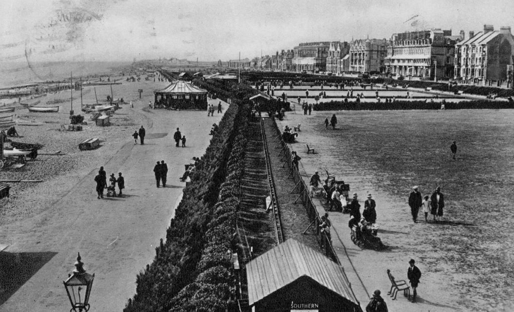
This is a view west from The King Alfred. From July 1928 until the start of the Second World War a miniature steam railway was operated for public rides on Hove Seafront during the summer months. The bowing greens are top right - they remain today... is this what the site needs going forward?!!
Brighton Bootcamp is very popular on the Western Lawns - very Brighton! The site should respond to a changing demographic and the recreational needs of residents and visitors alike.
The idea of integration Shoreham Harbour was positively received, although the suggestion was that the site as whole was quite a large under taking.
Shoreham Port with Hove Lagoon at the bottom of the picture - linking the two areas is an interesting dilemma. Tom Turner suggested planning 30 years ahead to allow for redefinition of the industry. I'm sure the planners would like to get their hands on this waterfront location.
Interestingly, Hove Lagoon used to be a tidal pond... I think the groynes were introduced around 1910 and the Lagoon as it is today was constructed in 1929 as a model yacht club, as illustrated in the first historical map. Today there is sailing and windsurfing on the Lagoon.
The skate Park was built about 7 years ago with a 12K donation for local resident Fat Boy Slim. Looking at the dilapidated tennis courts and the bowling green that are further east along the site, one of the questions raised during the crit was, "what is a place of pleasure and recreation now...?"
This is a view west from The King Alfred. From July 1928 until the start of the Second World War a miniature steam railway was operated for public rides on Hove Seafront during the summer months. The bowing greens are top right - they remain today... is this what the site needs going forward?!!
Brighton Bootcamp is very popular on the Western Lawns - very Brighton! The site should respond to a changing demographic and the recreational needs of residents and visitors alike.
Tuesday, 5 February 2013
Wave Energy: 'Push - Pull'
A visit to beach made me think about the energy in waves - the push-pull action of wind and gravity, acting as a manipulator of the shoreline...
Rubber slipway on the beach was interesting, made me think about exposing and revealing layers of the landscape. Perhaps the action of the sea peels back the layer...?
Peeling back the layers, a result of reciprocal push-pull action.
Negative spaces created by action... revealed voids capture material and 'reprogram' the shoreline.
'Push - Pull - Capture'
Studio 21_01_13
Bit of a pier group brainstorm, followed by tutorials with James and Nick... talked about the slush model and the overall concept of encouraging permeation of sea into the land as device to redefine the seafront. Talked about the groynes as interventions designed to manipulate drifting sediment.
We discussed the idea of manipulation of long shore drift, moreover the manipulation of natural processes. This came to mind... Worthing beach after a cargo ship shed it load of timber in Jan 2008:
Groynes as collectors
Almost like thousand of dismantles groynes washing up... I quite like the concept of the shoreline being the epicenter of the disorder, the most ephemeral point.
Wave action shaping the shoreline (above). Groynes in place to prevent longshore drift.
Wave action performing 'ephemeral hard' landscaping... waves like bulldozers, pushing and forming the pebbles.
Open sea = calm, apparent order, shoreline = violent, disorder... slicing action controlled by groynes. What would happen if the groynes were removed or reconfigured?
We discussed the idea of manipulation of long shore drift, moreover the manipulation of natural processes. This came to mind... Worthing beach after a cargo ship shed it load of timber in Jan 2008:
Groynes as collectors
Almost like thousand of dismantles groynes washing up... I quite like the concept of the shoreline being the epicenter of the disorder, the most ephemeral point.
Wave action shaping the shoreline (above). Groynes in place to prevent longshore drift.
Wave action performing 'ephemeral hard' landscaping... waves like bulldozers, pushing and forming the pebbles.
Open sea = calm, apparent order, shoreline = violent, disorder... slicing action controlled by groynes. What would happen if the groynes were removed or reconfigured?
Monday, 4 February 2013
Concept Model #1
This was the concept model of the major design site complete in the studio session, 14th January. I subsequently labelled it up for the site survey presentation - in essence it is supposed to represent the linear nature of West Hove seafront. The voids in the middle are the run down amenity areas (tennis courts, bowing green, basket ball courts) that run from east to west, towards Hove lagoon. The dead spaces.
This was developed further to illustrate the industrial area to the west of the site.
The main relationship between the promenade and the westerly industrial site should be investigated. Linking the two in a meaningful manner is one of the challenges. The hatched area below...
This was developed further to illustrate the industrial area to the west of the site.
The main relationship between the promenade and the westerly industrial site should be investigated. Linking the two in a meaningful manner is one of the challenges. The hatched area below...
Labels:
Models
Subscribe to:
Posts (Atom)